The 15th Street Interchange Is Already Being Built
Author
Phillip Shepard
Date Published
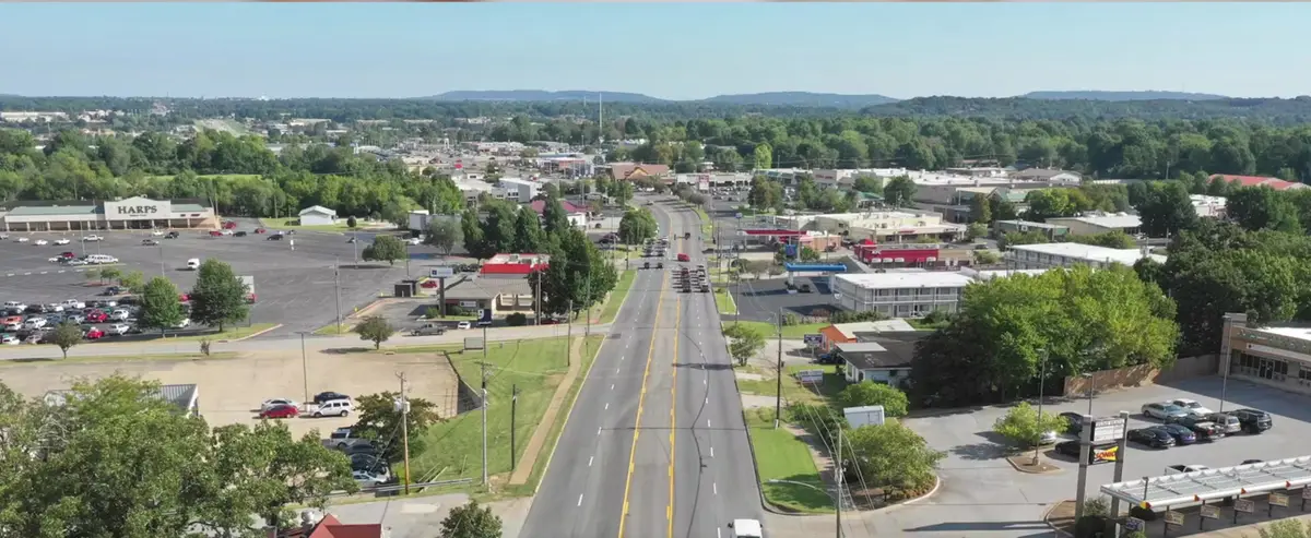
The 15th Street interchange has been under construction since 2025. I filmed this video treating it as something that might happen.
In this video I laid out what I thought were two possibilities: 15th Street "is for sure going to extend this way, cut over 49 and then hook up to MLK on this side... or another option is 15th Street's going to come down here and be its own essentially its own exit." I hedged the exit as a guess — "I assume it's going to be its own exit... so that's my opinion" — and put the timeline at "3 to 5, maybe 7 years."
Both things are happening, they're the same project, and it was approved by the Arkansas Highway Commission years before I filmed.
15th Street gets extended across I-49 on a new overpass and gets its own interchange. Construction began in 2025. As of early 2026 the plan was for 15th Street to open in phases with the interchange opening by the end of that year. Girders for the new bridge were being set during overnight I-49 closures.
So the thing I was weighing as a possibility was already funded, approved and being built. I hedged the exit form as "my opinion," which was the right instinct about my own certainty — I just never checked whether anyone had already decided.
What the project actually is
It's part of the roughly $100 million state reconstruction of the I-49 and Highway 62 (MLK) interchange — a city and state partnership originally scoped around $50 million for the two interchanges together. The full MLK project wraps in 2028.
Two details worth pinning down, since I was pointing at a map rather than naming streets:
The new construction runs west. 15th Street already exists east of I-49 — east of College Avenue it's signed Arkansas Highway 16. The extension takes it west across the interstate to the S. Futrall Drive and S. Shiloh Drive frontage roads, with a roundabout anchoring each end of the bridge.
And it connects to MLK indirectly. I said it would "hook up to MLK." It ties into Futrall and Shiloh, the frontage roads running north to the MLK interchange — same overall project, one step removed.
MLK and Wedington both check out
I said "MLK is going to be redone in the next year or so, once Weddington is done."
Correct on both, and the sequencing was right.
Wedington is Highway 16 West — the opposite end of the same Highway 16 that becomes 15th Street. Its I-49 interchange rebuild was a $37.6 million contract, and it ran ahead of the MLK work exactly as I described. Worth knowing it sits in west Fayetteville, a couple of miles north on I-49, so it's the precedent for this corridor work rather than part of the southern stretch itself.
MLK is being redone, in two separate ways. The state's interchange reconstruction is actively underway — the old I-49 overpass at MLK was removed in July 2026. And separately, Question 6 of the March 2026 city bond funds upgrades to Huntsville Road and MLK from Crossover Road to School Street. That's the east MLK segment — the one actually in this video's frame.
That bond passed at $375.5 million across nine questions.
The Elkins utilities — I read the construction right
I opened this section by admitting a blind spot — "notoriously I have been avoiding Elkins, and the reason being is because there's really no good way to get from Elkins to 49." That's worth keeping, because it's the setup for the observation I was proudest of and least sure about: driving Highway 16 toward Elkins, "you will tell that they are running sewer systems and they're running water from Fayetteville down this huge area," and I inferred Fayetteville was building capacity ahead of growth.
That's correct, and the city says so in writing.
The Highway 16 East Utility Relocations project relocated and upgraded water and sewer infrastructure between Stone Bridge Road and Roberts Road, upsizing the existing 8-inch waterline to 18-inch. The city's stated purpose is to "ensure long-term capacity is available to the Elkins area, which is served through wholesale metering by the City of Fayetteville Utilities Department."
The contract was awarded in March 2024 and the work completed in summer 2025.
And on who supplies Elkins: Fayetteville is the wholesale supplier of both water and sewer. Its water system serves Elkins, West Fork, Mount Olive Rural Water and Washington Water Authority at wholesale; its sewer system serves Elkins. Elkins runs its own department for distribution and billing inside city limits.
One honest refinement. The trigger for that construction was the state widening Highway 16 — it's a utility relocation, required by the road project, not a growth-driven extension the city launched on its own. But Fayetteville explicitly used the opportunity to upsize for Elkins-area capacity, which is the thing I was pointing at. So the inference holds; the causation is one step removed from how I told it.
Lake Wilson holds up
I described it as "not the prettiest of lakes, but I shouldn't say that, it's very pretty," secluded with gravel-road access, trails, "no beaches down there but you can put your kayak there."
All correct. Lake Wilson Park is a City of Fayetteville park in southeast Fayetteville — roughly 320 acres of land with 28 acres of water. It was Fayetteville's original water supply reservoir until the city stopped using it in the 1960s, when Beaver Water District became the regional source. Boating, fishing, hiking and picnicking are permitted, there's a nature trail running mostly through woods, and an off-leash dog area.
Kayaking is allowed and needs no permit — unlike Lake Fayetteville, which requires a boat permit.
And there's a detail behind "no beaches" worth adding. Wading and swimming are prohibited in all City of Fayetteville lakes — so it isn't just that there's no sand, there's no legal swimming at all. Worth knowing before you take kids.
Lake Sequoyah is the one I got wrong
I said the land around Lake Sequoyah — the audio garbles the name, but that's what I meant — could "be eventually commercial potentially, it could be residential, whatever the case is."
The City of Fayetteville bought the property in 1958, and Lake Sequoyah Park is approximately 1,400 acres of land with 389 acres of water. The land around that lake is overwhelmingly city-owned public parkland, not a development pipeline.
It functions as a park — boat ramp, courtesy dock, hiking trails, picnic areas, a no-wake lake with no permits required for boating or fishing, and swimming prohibited like the others.
There's also a physical constraint I didn't know about: heavy sediment accumulation from the Middle Fork of the White River has compromised or reduced many of the lake's long-term uses, and it sits in a 180-square-mile catchment feeding the regional drinking water supply downstream.
I don't know of a specific protective zoning overlay and won't claim one. The 1,400 acres already in public ownership is the fact that matters.
The thread I didn't see
Here's what I'd say if I made this video again, because it's a better story than the one I told.
Highway 16 is 15th Street. The Wedington interchange at one end, the MLK and 15th Street interchanges in the middle, and the Elkins water main at the other end are all points on a single corridor. And every one of them is funded and in the ground.
I was treating them as separate signals to read and extrapolate from. They're one program, already committed, with a public record I could have looked up.
Two things about how I framed it
My timeline contradicted itself. I said southeast Fayetteville "is going to do very well for itself in the next two years," and then said the trigger "is not going to really start for about 3 to 5, maybe 7 years tops." Same catalyst, two different horizons in one video.
And I said something I can't support: "a lot of land's already been purchased, a lot of developers are building homes with the anticipation this is coming down the pipeline." I don't have permit or platting data showing speculative buying ahead of the interchange. That's a claim that moves money, and I stated it as observed fact.
What I can say is that the infrastructure is real and public. What any of it does to a specific parcel is a question for a lender, an accountant and someone walking the actual street with you — not a prediction from a video.
One last thing I'd cut. Describing Lake Wilson, I mentioned "some gravel roads that people hang out at, sometimes college students, so that might go to the wayside in the future." That's a vague insinuation about unnamed people and it doesn't belong in a video about roads and utilities.