College Avenue Is Keeping Its Center Turn Lane
Author
Phillip Shepard
Date Published
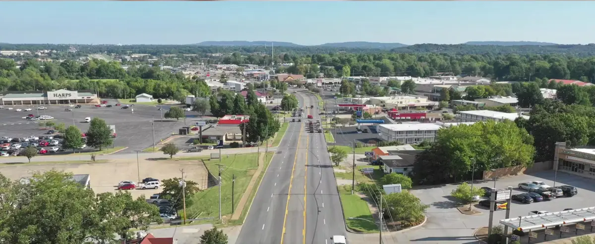
College Avenue is keeping its center turn lane. In this video I said the plan is not to hold onto the five-lane section — "comparison to adding another fifth lane in the section — they don't want to keep that there anymore." That's the clearest error in the video, and it's the one that changes what you should expect the finished road to look like.
The center turn lane mostly stays
College Avenue keeps two through lanes in each direction plus a center turn lane. The 71B Corridor Master Plan says North College between North and Millsap "would retain four through lanes with a raised median or a two-way center turn lane, depending on specific contexts and access needs" — turn lanes stay "where land use patterns make [medians] impossible."
The current design concept for the Sycamore-to-Township segment confirms it: two lanes of traffic in each direction with a turn lane in the middle, and overall roadway width reduced by only a couple of feet.
Medians are going in, but intermittently — so the turn lane does disappear in stretches, which is partly what I was reaching for. What's wrong is the flat version: the five-lane cross-section isn't being retired along North College. It's being interrupted.
Where I think I got confused: there is a five-lanes-to-three road diet in the plan. It's for South School Avenue, not College. Two different roads, both technically 71B, and I merged them.
"A lot more turn-offs" is backwards
I said the project adds "a lot more turn-offs."
The design deliberately reduces access points. Fewer driveways is a stated safety measure — the master plan identifies five-lane sections with abundant uncontrolled curb cuts as exactly where crashes cluster, and calls for consolidating curb cuts through shared driveways, interconnected parking lots and slip lanes.
The only sense in which "more turn-offs" holds is that the plan adds real signalized intersections — a new signal at College and Poplar serving the new Ramay Junior High, for instance. More intersections, fewer driveways. I said the opposite of half of that.
The south end: right that something got built, wrong about what
I said "if you've been around the area for maybe about a year or so, they just redid the south end of Fayetteville College Avenue — big additions, kind of spread everything out."
Something real did get finished recently. It just wasn't the south end of College Avenue.
South School Avenue — the actual south end of 71B — is still in design. Plans are under federal review, public input was gathered in December 2025, and construction is anticipated in 2027. The concept a Council committee backed in February 2026: two 11-foot travel lanes plus an 11-foot turn lane, 10 feet of on-street parking, 11 feet of sidewalk and trees.
What did finish on the south end is a different project: the Archibald Yell Boulevard safety improvements, complete by 2023 — traffic calming, lane reconfiguration, a bike and pedestrian lane, a new signal, and intersection work at College and South. The street was renamed Nelson Hackett Boulevard during that work, which is worth knowing if you're looking for it on a map.
There's also a real possibility I was describing the Maple-to-North segment of College itself, which is finished: ten-foot sidewalks on the west side, decorative lighting, street trees in grates, signal upgrades, reduced curb cuts, utilities buried. That's downtown-adjacent, not the south end.
The Lafayette-to-Dickson medians are from 2009
I described a completed segment "between Lafayette Street as well as Dickson Street, kind of adding some medians of that nature."
Those landscaped median islands were essentially complete in August 2009, with tree planting later that year. They came out of the 2006 sales tax bond street program covering Rock to Maple — a decade before the 71B Corridor Master Plan existed.
I didn't date them on camera, so this isn't a correction so much as a caution: if you're using those medians as a mental picture of what the current work will produce, they're sixteen years old and came from a different program.
What the project actually is
Since I described it loosely, here's the real shape of it.
It's the Highway 71B Corridor Improvement Project, guided by a master plan adopted in 2019. The lead agency is the City of Fayetteville Public Works Department — the city took jurisdiction in a 2019 transfer negotiated with the state highway department, covering 71B between the north and south Fulbright Expressway interchanges.
Funding: the April 2019 street bond, plus $4.8 million in federal aid on the current segment, plus a $25 million federal Safe Streets and Roads for All grant awarded in December 2023 on a 75/25 split. The 2026 bond is a backstop for overruns, not the main source.
The phasing, south to north:
- Maple to North Street — complete
- North Street to Sycamore — under construction, started February 24, 2025, now estimated complete May 2026
- Sycamore to Township — public input May 2026, construction beginning 2027, roughly $9 million in grant money plus a $3 million city match
- Beyond that, the plan covers North College to the city limits near Lake Fayetteville and the mall
So my "the whole corridor of College Avenue is going to change drastically in the next like 5 years" is roughly right on scale and probably optimistic on timing — the segment under construction when I filmed has already slipped twice, from November 2025 to January 2026 to May 2026.
The design elements I described correctly
Wider sidewalks and landscaped medians with tree cover. Confirmed. The Sycamore-to-Township concept has continuous sidewalks on both sides, street trees, new lighting, sheltered bus stops, pocket parks — one at the Green Acres Road triangle, one by the new junior high — and medians with vegetation.
A detail I'd have enjoyed: the medians carry a Fay Jones-inspired artistic theme, chosen by the Fayetteville Arts Council in December 2022 over a competing "Googie" roadside-architecture concept. Given that Fay Jones built Thorncrown Chapel an hour up the road, that's a better piece of local specificity than anything I came up with on camera.
Traffic calming is the stated intent. Medians are explicitly described as a way to encourage drivers to go slower. So when I said "it kind of honestly slows traffic down in the main area. That's debatable whether it's good or bad" — I had that right, and the hedge was the correct call. The only thing I'd add is that the slowing is deliberate. It's the design goal, not a tradeoff the city is quietly accepting.
The slowdown people are actually experiencing is construction
Worth separating, because I ran the two together.
The documented traffic problem right now is the build, not the finished design. Reporting in November 2025 described traffic at a standstill at peak hours, business entrances blocked or rerouted, and sidewalks moving week to week. A vintage store on the corridor reported revenue down close to 50% in months that are normally busy — roughly $17,000.
Businesses asked the city for better communication and asked customers to be deliberate about still showing up; a local editorial urged people not to abandon College Avenue businesses during the work. That's not opposition to the project. One owner's framing: once it's done it will positively impact the whole stretch, it's just the growing pains right now.
On the finished design, the closest thing to a documented objection came at the May 2026 open house, where a resident argued the concepts may not adequately serve the street once the new Ramay Junior High opens and wanted more coordination between the city and the school district. Others at the same session were supportive.
On the traffic numbers: volumes rise as you go north — 12,000 to 15,000 vehicles a day south of MLK, 18,000 to 19,000 on Nelson Hackett, mid-20,000s through downtown, peaking around 37,000 at Joyce Boulevard. I couldn't find a published level-of-service study for the finished cross-section, so I can't tell you what the completed road will do to your commute, and neither could I on camera.
Bikes north of Dickson — right, and the fix isn't what you'd expect
I said north of Dickson "it gets a little wonky when it comes to actual space for riding bikes... it's not a very great experience," and that it's "one major section that has been kind of ignored."
Correct, and well documented. North College has no continuous dedicated bike facility. The existing pieces are piecemeal: experimental protected lanes installed in 2018 through Fiesta Square and along Rolling Hills, a Poplar Bikeway that's only a signed shared roadway, and an acknowledged gap between the Appleby lanes and the Rolling Hills lanes.
Here's the part I'd want people to know: the plan's answer is to route cyclists off College, not to put a bike lane on it. It calls for an off-street shared-use path network that approximately parallels North College on both sides, running behind buildings and through parking lots. And in the Sycamore-to-Township concept, pedestrians and cyclists share the sidewalk — a shared-use sidepath, not a separated lane.
Whether that's the right call is a real debate. But if you're expecting a protected bike lane on College Avenue when this is finished, that isn't the plan.
Trails — right in substance, one thing backwards
I said "there are so many trail systems and pathways that are wanting to link up to that section of 71" and that the project will "make a master plan for more trail systems and more pathways to be able to hook up to business 71."
Trail connections are genuinely in scope. But the master plan already exists — it was adopted in 2019. The project implements it rather than creating it.
What's actually in it: the Razorback Greenway parallels the corridor and crosses 71B at two points, near Lake Fayetteville to the north and near MLK to the south. The Mud Creek and Town Branch trails connect the Greenway to 71B; Cato Springs and Tsa-La-Gi also lead to the corridor. On-street bikeway connections come in at Sycamore, Poplar and Appleby. A future Sublett Creek Trail would run from Mission and North to College and Poplar. Named project elements include a Cato Springs-to-Town Branch connection, a South School-to-Walker Park connection with new creek bridges, and an east-side College Avenue connection to the Mud Creek Trail.
So when I said "there's only been a couple intersections on 71 for that kind of pathway intersection" — that's right. Two Greenway crossings, with several feeder trails coming in.
The 15% claim, one more time
I make this claim again here, and more confusingly than anywhere else. First: "if there's a new subdivided piece of land commercial space, 15% of that actual space — of the actual buildout — the actual funding has to be used for outdoor spaces." Then, restated as money: "they have to dedicate this much money to the outdoor spaces." And then I vouched for it hard — "Fayetteville has that in the book and they never sway from that, I guarantee. Oh my God, no."
Notice I switch between "15% of that actual space" and "the actual funding" inside a single sentence. I wasn't sure myself, and I guaranteed it anyway.
The answer: it's area, not money. Fayetteville's Tree Preservation and Protection code sets a minimum tree canopy coverage as a percentage of the site, by zoning district — 15% in C-2 Thoroughfare Commercial, C-3, Urban Thoroughfare and the industrial districts. There is no percentage-of-construction-budget requirement anywhere in the code. It also covers trees specifically, not trail connections or bike racks; bicycle parking is a separate requirement with its own rules.
I've written that up in full in the post on the bike-ranking video. Same error, and this is the version where I was least sure and most emphatic — which is a combination worth watching for.
I also repeat here that "Fayetteville has been rated one of the best biking cities in America." That's from the 2020 PeopleForBikes ratings; the current 2026 numbers have Fayetteville at 49 out of 100, 425th nationally and third in Arkansas. Same post covers it.
The rezoning, and the one genuine insight
The zoning half of this video is the 71B Corridor rezoning, which I've corrected at length elsewhere: the City Council approved a new Urban Corridor district on September 17, 2024, rezoning roughly 586 acres along North College and South School from commercial-only to mixed-use.
I said at filming that "it's already been passed" and the signs were up with another meeting coming. That's a reasonable description of being mid-process.
On "for the last 50, 60 years it has all been zoned commercial" — directionally right, and I couldn't pin the date. The city's own planning history document is a dead link now. What is documented is that the corridor's commercial character consolidated in exactly that window: the 71 Drive-In opened in 1949 on what's now Fiesta Square, Evelyn Hills — the first large center outside downtown — opened in 1960, Southgate developed in 1965, land for the Fulbright interchange was acquired in 1967, the mall opened in 1972, and the widening projects that produced today's road section were 1970s work. And the pre-2024 zoning is confirmed: nearly all parcels fronting North College between North Street and the Fulbright interchange were zoned C-2 Thoroughfare Commercial.
So: built out and zoned as a highway-commercial strip since roughly the 1960s and 70s. That's the sourced version of what I said.
And the mechanism I identified is the best thing in the video. I said "a lot of the reason some of the businesses haven't sold is because [buyers] don't want to put another commercial space there. So they're probably going to take older buildings, tear them down, and put more townhouse condo style, maybe below they're going to have coffee shops."
That's a genuinely sharp read of why single-use commercial zoning strands property, and the master plan's own analysis backs the premise: building coverage along 71B is very low while parking and impervious coverage are very high, with large commercial sites built to parking ratios "based on highly seasonal loads and are rarely achieved, today around Christmas." Survey respondents ranked redeveloping vacant and deteriorating buildings among their top priorities.
I just couldn't find a current corridor-specific retail vacancy rate to put a number on it, so treat the scale of it as undocumented even though the pattern is well established.